-
1 geographical information system
географическая информационная система
—
[ http://www.iks-media.ru/glossary/index.html?glossid=2400324]Тематики
- электросвязь, основные понятия
EN
Англо-русский словарь нормативно-технической терминологии > geographical information system
-
2 Geographical Information System
сокр. GIS, = Geographic Information Systemгеографическая информационная система (сокр. ГИС) (комплекс средств для поддержки, обработки и выдачи картографических и связанных с ними данных в различных формах)English-Russian library and information terminology dictionary > Geographical Information System
-
3 geographical information system
English-Russian dictionary of geology > geographical information system
-
4 geographical information system
Англо-русский словарь по экологии > geographical information system
-
5 Geographical Information System
1) География: GIS2) Нефть и газ: Геоинформационная система, Геологическая информационная системаУниверсальный англо-русский словарь > Geographical Information System
-
6 geographical information system
1) География: GIS2) Нефть и газ: Геоинформационная система, Геологическая информационная системаУниверсальный англо-русский словарь > geographical information system
-
7 geographical information system
English-Russian information technology > geographical information system
-
8 geographical information system (GIS)
<01> географическая информационная система (ГИС), геоинформационная системаАнгло-русский геоэкологический словарь > geographical information system (GIS)
-
9 global positioning system/geographical information system
Универсальный англо-русский словарь > global positioning system/geographical information system
-
10 global positioning system/geographical information system
глобальная система навигации и определения местоположения и географическая информационная системаАнгло-русский словарь нефтегазовой промышленности > global positioning system/geographical information system
-
11 Geographical, Environmental and Siting Information System
Универсальный англо-русский словарь > Geographical, Environmental and Siting Information System
-
12 Geographic Information System
сокр. GIS, = Geographical Information Systemгеографическая информационная система (сокр. ГИС) (комплекс средств для поддержки, обработки и выдачи картографических и связанных с ними данных в различных формах)English-Russian library and information terminology dictionary > Geographic Information System
-
13 system
1) система || системный3) вчт операционная система; программа-супервизор5) вчт большая программа6) метод; способ; алгоритм•system halted — "система остановлена" ( экранное сообщение об остановке компьютера при наличии серьёзной ошибки)
- CPsystem- H-system- h-system- hydrogen-air/lead battery hybrid system- Ksystem- Lsystem- L*a*b* system- master/slave computer system- p-system- y-system- Δ-system -
14 system
n1) система2) способ; метод3) сеть4) строй•to deploy a system — размещать / разворачивать систему (напр. обороны)
to formulate a system — разрабатывать / вырабатывать систему
to overhaul / to reform a country's political system — перестраивать политическую систему страны
- abolition of the systemto set up a system — создавать / учреждать систему
- accounting system
- administrative system
- advanced system
- advantages of the system
- air-based system
- aircraft telecommunications system
- antagonistic systems
- anti-ballistic missile system
- anti-missile defense system
- anti-missile space defense system
- anti-satellite systems
- ASAT systems
- authoritative system
- automated management systems
- automated system
- automatic control system
- automatic data processing system
- banking system
- bipartisan system
- biparty system
- bonus system
- break-up of the system
- British entry into the European Monetary System
- bureaucrat system
- capitalist economic system
- capitalist system
- career development system
- centrally planned system
- clan system
- classified national defense system
- collapse of the system
- collective security system
- communal system
- communications system
- competitive price system
- complex system
- comprehensive system
- compulsory purchase system
- computer system
- constitutional system
- contract system
- control system
- conventional system
- country programming system
- credit and banking system
- credit system
- crisis of the system
- cultural system
- currently-operating system
- decentralized system
- defense system
- deficiency of the system
- delivery system
- democratic political systems
- deterrent system
- different social systems
- disintegration of the system
- distribution system
- dynamic international system
- early warning system
- ecological system
- economic system
- educational system
- effective system
- efficient system
- election system
- electoral system
- electronic system
- EMS
- European Monetary System
- exploitation system
- exploiting system
- fair system
- family-planning system
- federal grant system
- finance and credit system
- financial system
- first-past-the-post voting system
- forecasting system
- formation of the system
- free enterprise system
- free market system
- generalized system of preferences
- global system
- grid system
- ground-based system
- health care system
- health system
- historically established system
- home security system
- immunity system
- industrial system
- inequitable system
- information system
- INIS
- institutional system
- integrated system
- intelligence system
- International Nuclear Information System
- international system
- International Trusteeship System
- irrigation system
- job-by-job system of payment
- judicial system
- land tenure system
- land-based antiballistic missile system
- legal system
- liberalization of the political system
- life-support system
- majority system
- management system
- managerial system
- mandate system
- mandatory system
- market system
- mayor-council system
- merit system
- metric system
- missile and satellite detection system
- missile delivery system
- misuse of the judicial system for political purposes
- monarchical system
- monetary and credit system
- monetary system
- monitoring system
- monopolistic system
- motor-road and railway system
- multifaceted system
- multilateral payments system
- multiparty system
- mutually-acceptable system
- national accounting and control system
- national defense system
- new arms systems
- noncapitalist system
- obsolete social system
- old system
- one-man-one-vote system
- one-member-one-vote system
- one-party system
- opposing social systems
- optimum system
- outmoded system
- overhaul of the tax system
- parliamentary system
- party system
- payments system
- pension system
- people's democratic system
- philosophical system
- planning system
- political system
- post adjustment system
- power system
- preferential system
- premium system
- presidential system
- price system
- private enterprise system
- program budgeting system
- proportional representation system
- public pension system
- records system
- regimented political system
- remnants of the system
- reports system
- republican system
- ruling system
- safeguards system
- satellite-tracking system
- sea-based system
- security system
- social security system
- social system
- socio-economic system
- socio-political system
- space defense system
- space weapons systems
- space-based system
- spoils system
- stability system
- stable system
- state political system
- state system
- state-managed social security system
- strategic nuclear-weapon systems
- submarine-based system
- supply system
- system of collective security
- system of exploitation
- system of geographical distribution
- system of government and public organizations - taxation system
- technologically advanced weapons systems
- territorial system
- training system
- transition to a multiparty system
- tribal system
- trusteeship system
- two-party system
- united economic system
- visa system
- voting system
- wage system
- world system
- world trading system -
15 GIS
1) Общая лексика: Стандарт Института золота (Gold Institute Standard)2) Геология: Геологическая информационная система3) Биология: gonadotropin-inhibititing substance4) Американизм: Geographic Information Systems5) Военный термин: Government Information System, generalized information system, ground instrumentation system7) Сокращение: Gas-Insulated Switch, Geospatial Information System, Global Information System8) Вычислительная техника: Graphical Information System9) Нефть: genetic increment of strata10) Транспорт: Geographical Information Systems11) Деловая лексика: Generic Inventory System12) Глоссарий компании Сахалин Энерджи: geoinformation system, ГИС, геоинформационная система13) Сетевые технологии: Geographic Information System, Geographical Information System, географическая информационная система, система обработки географической информации14) Автоматика: general information system15) Макаров: географические информационные системы16) Расширение файла: Generalised Information System, Global Information Solutions (AT&T), Bitmap graphics (Erdas gray-scale image)17) Энергосистемы: аванпост18) Нефть и газ: Geologic Information System, Geological Information System19) Электротехника: gas-insulated substation, gas-insulated switchgear, КРУЭ20) Должность: Geographic Information Science21) NYSE. General M L S, Inc.22) Аэропорты: Gisborne, New Zealand23) НАСА: Geography In Space -
16 GIS
- свидетельство
- КРУ с газовой изоляцией
- комплектное распределительное устройство элегазовое
- комплектное распределительное устройство с элегазовой изоляцией
- глобальное информационное общество
- ГИС
- географическая информационная система (ГИС)
- географическая информационная система
- газоизолированная подстанция
- выключатель элегазовый
- выключатель с газовой изоляцией
выключатель с газовой изоляцией
—
[А.С.Гольдберг. Англо-русский энергетический словарь. 2006 г.]Тематики
EN
выключатель элегазовый
Выключатель газовый, контакты которого размыкаются и замыкаются в элегазе (шестифтористой сере).
[ ГОСТ Р 52565-2006]EN
sulphur hexafluoride circuit-breaker
SF6 circuit-breaker
a circuit-breaker in which the contacts open and close in sulphur hexafluoride
[IEV number 441-14-31]FR
disjoncteur à hexafluorure de soufre
disjoncteur à SF6
disjoncteur dont les contacts s'ouvrent et se ferment dans l'hexafluorure de soufre
[IEV number 441-14-31]Для РУ напряжением 110 кВ и выше (вплоть до 1150 кВ) наиболее широко используются воздушные выключатели, где гашение дуги осуществляется потоком сжатого воздуха. Однако в последнее время они вытесняются элегазовыми выключателями, в которых в качестве дугогасящей среды используется электроотрицательный газ — шестифтористая сера (элегаз). Такие выключатели создаются для герметичных распределительных устройств (ГРУ), а также для наружной установки. Использование элегаза в качестве дугогасящей среды обусловлено его высокими изоляционными и дугогасящими свойствами. Это позволяет создать более совершенные выключатели с меньшим числом дугогасительных разрывов, с меньшими габаритами и более надежные в эксплуатации.
[А. И. Афанасьев и др. Электрические аппараты высокого напряжения. - 2-е изд., доп. СПбГТУ, 2000, 503 с.]Тематики
- выключатель, переключатель
- высоковольтный аппарат, оборудование...
EN
DE
FR
ГИС
Географическая информационная система
геоинформационная система
Информационная система, обеспечивающая сбор, хранение, обработку, доступ, отображение и распространение пространственно-координированных данных (пространственных данных). ГИС содержит данные о пространственных обьектах в форме их цифровых представлений (векторных, растровых, квадротомических и иных), включает соответствующий задачам набор функциональных возможностей ГИС, в которых реализуются операции геоинформационных технологий, или ГИС-технологий (GIS tehnology), поддерживается программным, аппаратным, информационным, нормативно-правовым, кадровым и организационным обеспечением. По территориапьному охвату различают глобальные, или планетарные ГИС (global GIS), субконтинентальные ГИС, национальные ГИС, зачастую имеющие статус государственных, региональные ГИС (regional GIS), субрегиональные ГИС и локальные, или местные ГИС (lokal GIS). ГИС различаются предметной областью информационного моделирования, к примеру, городские ГИС, или муниципальные ГИС, МГИС (urban GIS), природоохранные ГИС (environmental GIS) и т.п.; среди них особое наименование, как особо широко распространенные, получили земельные информационные системы. Проблемная ориентация ГИС определяется решаемыми в ней задачами (научными и прикладными), среди них инвентаризация ресурсов (в том числе кадастр), анализ, оценка, мониторинг, управление и ппантрование, поддержка принятия решений. Интегрированные ГИС, ИГИС (integrated GIS, IGIS) совмещают функциональные возможности ГИС и систем цифровой обработки изображений (материалов дистанционного зондирования) в единой интегрированной среде. Полимасштабные, или масштабно-независимые ГИС (multiscale GIS) основаны на множественных, или полимасштабных представпениях пространственных объектов (multiple representation, multiscale representation), обеспечивая графическое или картографическое вопроизведение данных на любом из избранных уровней масштабного ряда на основе единственного набора данных с наибольшим пространственным разрешением. Пространственно-временные ГИС (spatio-temporal GIS) оперируют пространственно-временными данными. Реализация геоинформационных проектов (GIS project), создание ГИС в широком смысле слова, включает этапы предпроектных исследований (feasibility stady), в том числе изучение требований пользователя (user requirements) и функциональных возможностей используемых программных средств ГИС, технико-экономическое обоснование, оценку соотношения "затраты/прибыль" (costs/benefits); системное проектирование ГИС (GIS designing), включая стадию пилот-проекта (pilot-project), разработку ГИС (GIS development); ее тестирование на небольшом территориальном фрагменте, или тестовом участке (test area), прототипирование, или создание опытного образца, прототипа (prototype); внедрение ГИС (GIS implementation), эксплуатацию и использование. Научные, технические, технологические и прикладные аспекты проектирования, создания и использования ГИС изучаются геоинформатикой.
[ http://www.morepc.ru/dict/]Тематики
Синонимы
EN
газоизолированная подстанция
Электрическая подстанция, оборудование которой заключено в металлический кожух, заполненный изолирующим газом.
[ ГОСТ 24291-90]EN
gas insulated metal-enclosed substation
a substation which is made up with only gas insulated metal enclosed switchgear
[IEV number 605-02-14 ]FR
poste sous enveloppe métallique à isolation gazeuse
poste ne comportant que de l'appareillage sous enveloppe métallique à isolation gazeuse
[IEV number 605-02-14 ]Тематики
EN
DE
- Gasoisolirte metaligekapselte Station
- Station, gasisolierte metallgekapselte
FR
географическая информационная система
—
[ http://www.iks-media.ru/glossary/index.html?glossid=2400324]Тематики
- электросвязь, основные понятия
EN
географическая информационная система
ГИС
—
[Упрощение процедур торговли: англо-русский глоссарий терминов (пересмотренное второе издание) НЬЮ-ЙОРК, ЖЕНЕВА, МОСКВА 2011 год]EN
geographic information system
GIS
[Trade Facilitation Terms: An English - Russian Glossary (revised second edition) NEW YORK, GENEVA, MOSCOW 2456]Тематики
Синонимы
EN
глобальное информационное общество
—
[Л.Г.Суменко. Англо-русский словарь по информационным технологиям. М.: ГП ЦНИИС, 2003.]Тематики
EN
КРУ с газовой изоляцией
—
[Я.Н.Лугинский, М.С.Фези-Жилинская, Ю.С.Кабиров. Англо-русский словарь по электротехнике и электроэнергетике, Москва, 1999 г.]Тематики
- электротехника, основные понятия
EN
комплектное распределительное устройство с элегазовой изоляцией
КРУЭ
-Параллельные тексты EN-RU
The circuit breaker forms the central element of the gas insulated switchgear.
[Siemens]Силовой выключатель является основным элементом КРУЭ.
[Перевод Интент]Switchgears of type 8DQ1 are metal-enclosed, gas-insulated switchgears for operating voltages up to 345 / 420 kV. They consist of individual switchgear bays.
[Siemens]КРУЭ 8DQ1 представляет собой комплектное распределительное устройство в металлической оболочке с элегазовой изоляцией на напряжение до 345/420 кВ. КРУЭ состоит из отдельных ячеек.
[Перевод Интент]These operating instructions are valid for the type and version of the metal-enclosed gas-insulated switchgear specified on the title page.
[Siemens]Данный документ представляет собой Руководство по эксплуатации комплектного распределительного устройства в металлической оболочке с элегазовой изоляцией (КРУЭ) тип и исполнение которого указаны на обложке.
[Перевод Интент]Тематики
- комплектное распред. устройство (КРУ)
Синонимы
EN
комплектное распределительное устройство элегазовое
РУ, в котором основное оборудование заключено в оболочки, заполненные элегазом (SF6), служащим изолирующей и/или дугогасящей средой.
[ПУЭ]EN
gas-insulated metal-enclosed switchgear
metal-enclosed switchgear in which the insulation is obtained, at least partly, by an insulating gas other than air at atmospheric pressure
NOTE – This term generally applies to high-voltage switchgear and controlgear
[IEV number 441-12-05]FR
appareillage sous enveloppe métallique à isolation gazeuse
appareillage de connexion sous enveloppe métallique dans laquelle l'isolation est obtenue, au moins partiellement, par un gaz isolant autre que l'air à pression atmosphérique
NOTE – Ce terme s'applique généralement à l'appareillage à haute tension.
[IEV number 441-12-05]
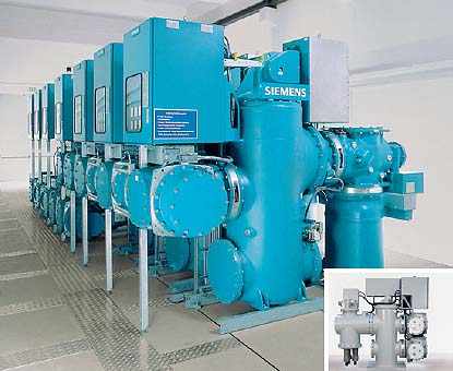 Рис. SiemensКРУЭ 8DN8
Тематики
- комплектное распред. устройство (КРУ)
Синонимы
Сопутствующие термины
EN
- gas-insulated metal-enclosed switchgear
- gas-insulated switchgear
- GIS
- SF6 gas-insulated metal-enclosed switchgear
DE
- gasisolierte, metallgekapselte Schaltanlagen
FR
2.1.35 свидетельство: Документ, официально подтверждающий какой-либо факт, имеющий юридическое значение, либо право лица (об окончании учебного заведения).
2.2. В настоящем руководстве применены следующие сокращения на русском языке:
АМИС
Автоматическая метеорологическая измерительная система
АМРК
Автоматизированный метеорологический радиолокационный комплекс
АМСГ
Авиационная метеорологическая станция (гражданская)
АМЦ
Авиационный метеорологический центр
БАМД
Банк авиационных метеорологических данных
ВМО
Всемирная метеорологическая организация
ВНГО
Высота нижней границы облаков
ВПП
Взлетно-посадочная полоса
ВС
Воздушное судно
ВСЗП
Всемирная система зональных прогнозов
ВЦЗП
Всемирный центр зональных прогнозов
ГАМЦ
Главный авиационный метеорологический центр
ГИС
Географическая информационная система
ГОУ ИПК
Государственное образовательное учреждение «Институт повышения квалификации»
ГСТ
Глобальная система телесвязи
ГУ ГРМЦ
Государственное учреждение «Главный радиометеорологический центр»
ДОТ
Дистанционные образовательные технологии
ИТ
Информационные технологии
КПК
Курсы повышения квалификации
КРАМС
Комплексная радиотехническая аэродромная метеорологическая станция
МРЛ
Метеорологический радиолокатор
НГЭА
Нормы годности к эксплуатации гражданских аэродромов
НОО
Непрерывное образование и обучение
НПР
Непрерывное профессиональное развитие
ОВД
Обслуживание воздушного движения
ОГ
Оперативная группа
ОМС
Орган метеорологического слежения
УВД
Управление воздушным движением
2.3. В настоящем руководстве применены следующие сокращения на английском языке:
AFTN
Aeronautical Fixed Telecommunication Network
Авиационная фиксированная сеть электросвязи
AIRMET
AIRman's METeorological information
Выпускаемая органом метеорологического слежения информация о фактическом или ожидаемом возникновении определенных явлений погоды по маршруту полета, которые могут повлиять на безопасность полетов воздушных судов на малых высотах
ATIS
Automatic Terminal Information Service
Автоматическая аэродромная служба информации
BUFR
Binary Universal Form for the Representation of meteorological date
Двоичная универсальная форма для представления метеорологических данных
GIS
Geographic Information Systems
Географическая информационная система
GAMET
General Aviation METeorological forecast
Зональный прогноз, составляемый открытым текстом с сокращениями для полетов на малых высотах применительно к району полетной информации или его субрайону (подрайону) метеорологическим органом и передаваемый метеорологическим органам соседних районов полетной информации
GRIB
GRIdded Binary
Бинарный код (прогностические данные метеорологических элементов в узлах регулярной сетки)
GTS
Global Telecommunication System
Глобальная система телесвязи (в рамках ВМО)
IAVW
International Airways Volcano Watch
Служба слежения за вулканической деятельностью на международных авиатрассах
ICAO
International Civil Aviation Organization
Международная организация гражданской авиации
ISCS
International Satellite Communications System
Международная спутниковая система телесвязи (обеспечивается США)
METAR
METeorological Aerodrome Report
Метеорологическая сводка по аэродрому (код METAR)
MOR
Meteorological Optical Range
Метеорологическая оптическая дальность
OPMET
Operational METeorological information
Оперативная метеорологическая информация (данные)
QFE
Atmospheric pressure at the runway threshold (or at the aerodrome elevation)
Атмосферное давление на уровне порога ВПП (или аэродрома)
QNH
Atmospheric pressure at the aerodrome elevation corrected to the mean sea level according to standard atmosphere
Атмосферное давление на уровне аэродрома, приведенное к среднему уровню моря по стандартной атмосфере
RVR
Runway Visual Range
Дальность видимости на ВПП
SADIS
SAtellite Distribution System
Спутниковая система рассылки метеорологических данных (обеспечивается Великобританией)
SIGMET
SIGnificant METeorological information
Выпускаемая органом метеорологического слежения информация о фактическом или ожидаемом возникновении определенных явлений погоды по маршруту полета, которые могут повлиять на безопасность полетов воздушных судов
SIGWX
SIGnificant Weather
Особые явления погоды
SPECI
SPECIal report
Специальная метеорологическая сводка (по аэродрому)
TAF
Terminal Aerodrome Forecast
Прогноз по аэродрому
TCAC
Tropical Cyclone Aadvisory Center
Консультативный центр по тропическим циклонам
TREND
TREND
Прогноз для посадки
VAAC
Volcanic Ash Advisory Center
Консультативный центр по вулканическому пеплу
VOLMET
Volume of meteorological information for aircraft in flight
Объем метеорологической информации для воздушных судов, находящихся в полете
Англо-русский словарь нормативно-технической терминологии > GIS
17 AEGIS
1) Общая лексика: hum. сокр. A European Genebank Integration System2) Медицина: Aids Education Global Information System3) Военный термин: Airborne Early Warning/Ground Environment Integration Segment, интегрированная система наведения ракетного оружия, комплекс, объединяющий радиолокационное оборудование и систему управления огнем4) Сокращение: Advanced Electronic Guidance and Instrumentation System, Advanced Engine / Gearbox Integrated System, Air Electronic Guidance Information System, Airborne Early Warning Ground Integration Segment5) Фирменный знак: Associated Electric Gas Insurance Services6) Образование: An Educational Geographical Information System, The Association Of Educational Guardians For International Students7) Программирование: глобальная информационная система по побочным действиям (Adverse Event Global Information System)8) Фантастика Alien Extermination Global Intercept System9) Программное обеспечение: Agent Engineering For Generation Of Information Systems18 Aegis
1) Общая лексика: hum. сокр. A European Genebank Integration System2) Медицина: Aids Education Global Information System3) Военный термин: Airborne Early Warning/Ground Environment Integration Segment, интегрированная система наведения ракетного оружия, комплекс, объединяющий радиолокационное оборудование и систему управления огнем4) Сокращение: Advanced Electronic Guidance and Instrumentation System, Advanced Engine / Gearbox Integrated System, Air Electronic Guidance Information System, Airborne Early Warning Ground Integration Segment5) Фирменный знак: Associated Electric Gas Insurance Services6) Образование: An Educational Geographical Information System, The Association Of Educational Guardians For International Students7) Программирование: глобальная информационная система по побочным действиям (Adverse Event Global Information System)8) Фантастика Alien Extermination Global Intercept System9) Программное обеспечение: Agent Engineering For Generation Of Information Systems19 aegis
1) Общая лексика: hum. сокр. A European Genebank Integration System2) Медицина: Aids Education Global Information System3) Военный термин: Airborne Early Warning/Ground Environment Integration Segment, интегрированная система наведения ракетного оружия, комплекс, объединяющий радиолокационное оборудование и систему управления огнем4) Сокращение: Advanced Electronic Guidance and Instrumentation System, Advanced Engine / Gearbox Integrated System, Air Electronic Guidance Information System, Airborne Early Warning Ground Integration Segment5) Фирменный знак: Associated Electric Gas Insurance Services6) Образование: An Educational Geographical Information System, The Association Of Educational Guardians For International Students7) Программирование: глобальная информационная система по побочным действиям (Adverse Event Global Information System)8) Фантастика Alien Extermination Global Intercept System9) Программное обеспечение: Agent Engineering For Generation Of Information Systems20 WGIS
1) Американизм: Washington Geographic Information System2) Техника: waste containment and isolation strategy3) Ветеринария: Wyoming Grasshopper Information System4) Телекоммуникации: Wireless Geographical Information SystemСтраницы- 1
- 2
См. также в других словарях:
geographical information system — /dʒi:əˌgræfɪk(ə)l ɪnfə meɪʃ(ə)n ˌsɪstəm/ noun a type of database which is sorted on geographical data, such as a census, or one which provides maps on screen. Abbr GIS … Marketing dictionary in english
Institute of Geographical Information System — Infobox NUST name = Institute of Geographical Information Systems motto = type = Public Sector established = location = Islamabad, Pakistan faculty = students = head title = Director head name = Dr. Umar Khan Khattak courses = website =… … Wikipedia
Geographical Operations System — A Geographical Operations System (GOS) combines the integration of data with geographic mapping ability in a consolidated process for telecommunications companies. The process can be defined as, “the marriage that integrating Geographic… … Wikipedia
Network information system — (abbreviation: NIS) is an information system for managing networks, such as electricity network, water supply network, gas supply network, or telecommunications network. NIS may manage all data relevant to the network, e.g. all components and… … Wikipedia
Geographical Names Information System — Geographic Names Information System oder GNIS ist eine Datenbank, die Namen und Informationen über den Namen und die Lage von nahezu zwei Millionen geographischen Objekten in den Vereinigten Staaten und den abhängigen Territorien enthält. GNIS… … Deutsch Wikipedia
Historical geographic information system — A historical geographic information system (also written as historical GIS or HGIS) is a geographic information system that may display, store and analyze data of past geographies and track changes in time. It can be regarded as a subfield of… … Wikipedia
Emergency Management Information System — (EMIS) is a computer database for disaster response that provides graphical, real time information to responders. [ cite web|url=http://www.giswebsite.com/lkc/refs/er/tsld001.htm |title=What is an Emergency Management Information System (EMIS)?… … Wikipedia
Geographic information system — GIS redirects here. For other uses, see GIS (disambiguation). A geographic information system, geographical information science, or geospatial information studies is a system designed to capture, store, manipulate, analyze, manage, and present… … Wikipedia
Geographic Names Information System — The logo of the United States Geological Survey The seal of the United States Board on Geogra … Wikipedia
Electronic Chart Display and Information System — An Electronic Chart Display and Information System (ECDIS) is a specific form of computer based navigation information system that complies with International Maritime Organization (IMO) regulations and can be used in lieu of paper navigation… … Wikipedia
BC Geographical Names Information System — The BC Geographical Names Information System (BCGNIS) is a geographic name database for British Columbia, which is run and maintained by the Base Mapping and Geomatic Services Branch of the Integrated Land Management Bureau . The database… … Wikipedia
 18+© Академик, 2000-2024
- Обратная связь: Техподдержка, Реклама на сайте
Экспорт словарей на сайты, сделанные на PHP, Joomla, Drupal, WordPress, MODx.
Перевод: с английского на русский
с русского на английский- С русского на:
- Английский
- С английского на:
- Все языки
- Испанский
- Итальянский
- Русский
- Хорватский